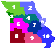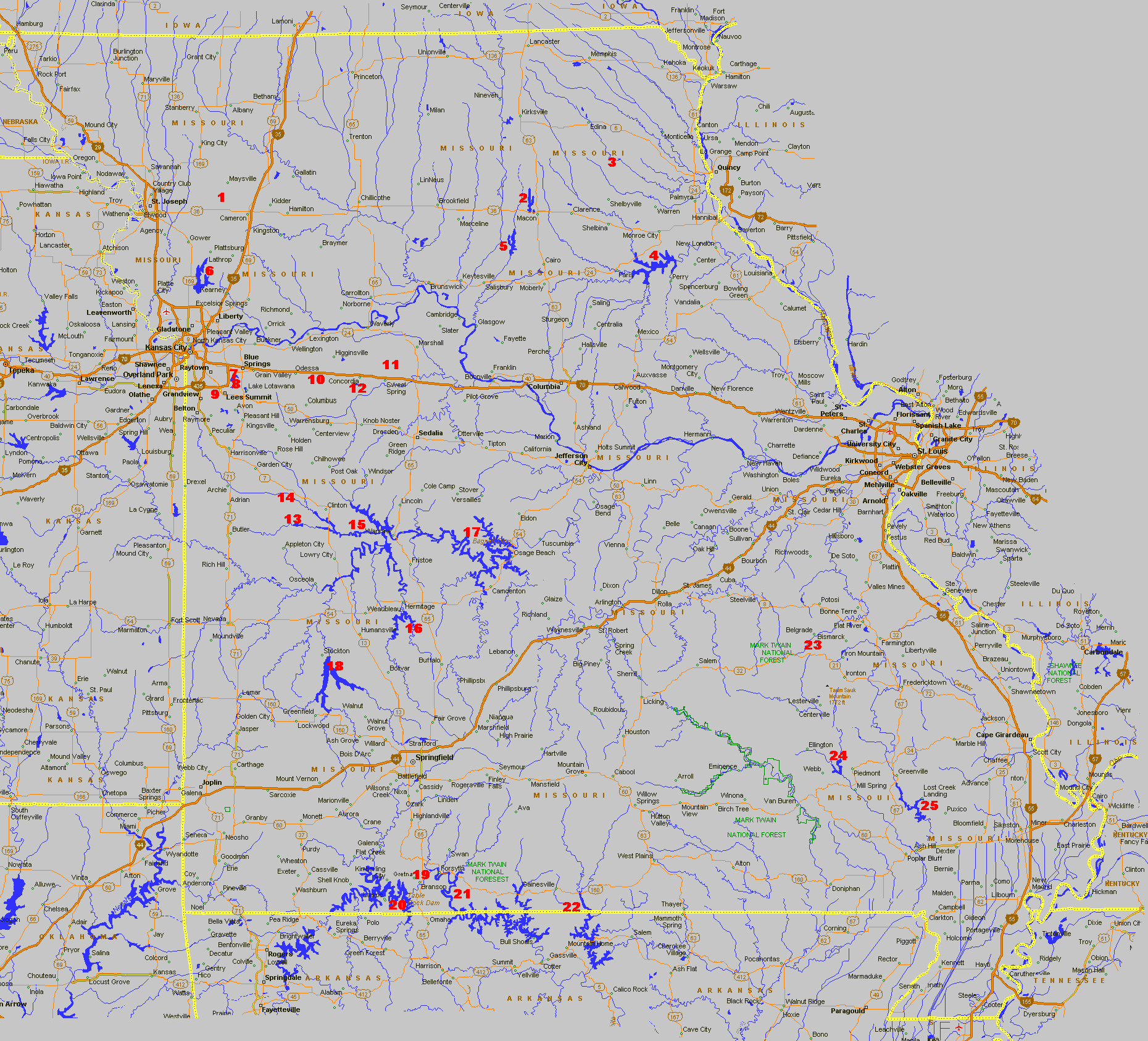
| Missouri Lakes Locator Map The Lakes are listed below, just choose the lake you want and correspond its number with the number on the map. Click on the number on the map for information for that lake. Below is a Region Map showing the different regions the lakes are located. |
|||||
This Map shows the Different
Regions
|
This Map shows the Different Regions
|
This Map shows the Different
Regions
|
This Map shows the Different Regions
|
||||
| Click on name of the lake for map. | Click on name of the lake for map. | ||||||
- |
- |
||||||
| Number | Lake Name | Acreage | Location | Number | Lake Name | Acreage | Location |
| 1. | Pony Express | - | 9 miles west of Cameron | - |
|||
| 2 Northeast Region | - |
13. | 1,500 | 12 miles South of Urich | |||
| 2. | Longbranch | 2,249 | 2 miles north of Macon | 14. | S. Grand River | 1/2 mile south of Urich | |
| 3. | Sever | 158 | 1 mile north of Newark | Truman | 56,000 | Spans from Clinton to Warsaw | |
| 4. | Mark Twain | 18,600 | 14 miles south of Monroe City | Pomme De Terre | 7,800 | 3 miles south of Hermitage | |
| 5. | Thomas Hill | 11,000 | 6 miles west & 8 miles south of Macon |
17. | Lake of the Ozarks | Spans from Warsaw to Osage Beach | |
| 3 Kansas City Region | - |
- |
|||||
| 6. | Smithville | 7,200 | 3 miles east of Smithville | - |
|||
| 7. | Blue Springs | 720 | 3 miles west of Blue Springs | 18. | Stockton | 24,900 | 1/2 mile east of Stockton |
| 8. | Jacomo | 3 miles west of Blue Springs | 19. | Taneycomo | 5 miles south of Branson | ||
| 9. | Longview | 930 | 2 mile east of Grandview | Table Rock | 43,100 | Kimberling City | |
- |
21. | Bull Shoals | 45,440 | Starts at Forsyth | |||
| 10. | Maple Leaf | 826 | 9 miles east of Odessa | - |
|||
| 11. | Blind Pony | 4 1/2 miles northeast of Sweet Springs | 22. | 22,000 |
8 miles east of Gainesville | ||
| 12. | Concordia Lake | - | - |
- |
|||
| 23. | Council Bluff | 440 |
18 miles south of Potosi | ||||
| 24. | Clearwater | 1,630 | 5 miles west of Piedmont | ||||
| 25. | Wappapello | 8,600 | 13 miles north of Poplar Bluff | ||||
If you would like to Advertise on Anglers Fishing Info, Click Here
Anglers Fishing Info Home page Classified Corner Lake Maps Contact Anglers Fishing Info
Arkansas Fishing Reports Kansas Fishing Reports Missouri Fishing Reports
Oklahoma Fishing Reports Nebraska Fishing Reports